Full disclosure, this hike was taken on May 2nd, 2020 I am writing about it on February 26th, 2021. I uh...it takes me a long time to do stuff.
So this is Wiliwilinui Ridge. This had been on our "to hike" radar for awhile, but we wanted to wait for a day with lots of cloud coverage and no rain to do it, because someone who is me was hospitalized for heat stroke a few years ago and has been crazy sensitive to heat ever since. There is little to no shade on this hike, it's all very open, very exposed. We found the perfect forecast for it, and set out to tackle this moderate (according to AllTrails) beast.
This is one of those hikes that you want to be first in line to get to. Since space is such a hot commodity on islands (go figure, right?), there really isn't room at the base of a lot of these hikes to just build spacious parking lots (and even if there were, I wouldn't want that. And it's obviously up to me). This particular hike starts at the very end of a gated community. You have to talk to the gate guard to get a pass, and then there is space for about 5 cars to park at the trail head. Outside of that, you have to park way down the hill and walk about a mile up before doing the 5 mile long trail. While Alltrails says this is a moderate trail, they're being kind of unfair. The last two miles is ALLLLL up stairs, very literally, and it's muddy and it sucks. It would be a difficult trail. Not hard, just difficult. And I don't know about adding two miles to the already not great 5 we already signed up for. I'm really glad Derek and I didn't have to do that, although I just checked the time stamps on these cell phone photos...we started the hike at 1pm. I guess we just got lucky that day!
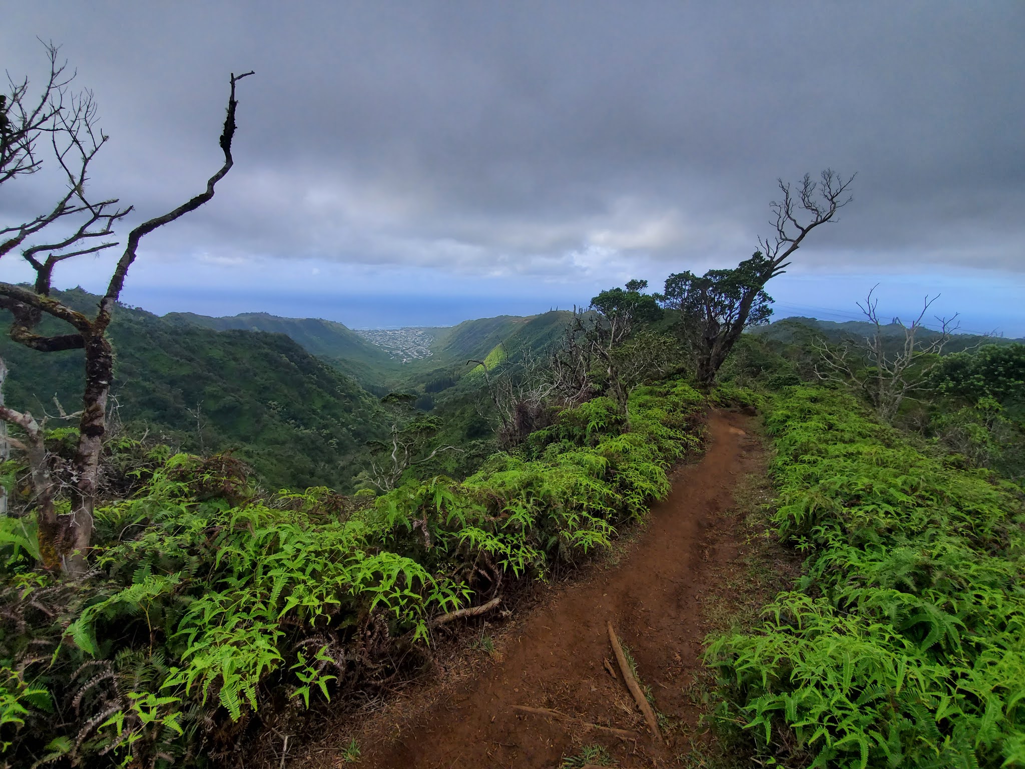
Here is the start of the trail, and it looks like it's going to be super easy. Flat, very flat. The wind was SO LOUD, though. Beautifully loud, and I loved it.
Here's my forever hot man piece, looking at the end of the hike from the beginning of the hike. You can juuuuuuust see the first summit we'd be reaching in the middle/left of the frame. I did take a shitty picture of the summits a little further in the hike, just to give some perspective of how fucking intensely steep the hike gets.


We walked along that kind of flatness for about a quarter mile, with no idea it was going to get more steep sooner rather than later. And then here comes the first incline!! It may not look that steep, but uh....

People added a rope to keep yourself balanced. And when it's muddy and slick, like it was the day we hiked this, it is a welcome addition to the trail.

Look at these views, though. Of course the views are prettier on a bright day with little to no cloud coverage, but there's something lovely about a grey day, too. Mostly the fact that I won't die of exposure.

Oh! Ok, so. Here is the part of the trail.....ish. I actually took it a little later, but it's close enough to count...where I took a picture of where we were headed. Here's the cell phone photo...

And here's the camera photo. It wasn't taken for artistic value, more for measure.

So you can kind of see the path you take to get to the top, but in case you cannot, I made this handy dandy edit just for you:

If you zoom in, you can see all the tiny little people!!! I was looking at that and thinking I had bitten off more than I could chew, but Derek isn't a quitter. I say I'm not, but I'm a liar. I live to quit.
Here is Derek, generously giving scale to the incline on this little hill, but I'm not sure he's selling it properly. He almost slid down this on the way back to the car, but in fairness to him, it was less a testament to how steep it is (though it is steep) and more a testament to the fact that our legs were melted jelly by the time we got back here. This isn't even a mile in.

I really a, a sucker for a gnarled, scraggly looking tree.

And we were on flat paths for awhile!!!

With luscious views. Just look at those valleys.


The flat path was starting to get a little bit rolling in nature, but it was totally bearable


Plus, it's just really hard to be annoyed or put out over ANYTHING when you have these views:


And this is where we're starting to get to the parts of the hike that I hated.


Here it is! Our first set, of many, many, MANY sets of stairs.

Derek takes the lead, for science:

And I take some shots of him, for scale:


If you're thinking, those don't look so bad! You're right. They were not so bad. They were not my first choice, but as stairs go, it was only going to go downhill from there. Pun intended.

Here we go again. And it's pretty non stop from here until the summit. Sometimes, the stairs are roots! Nature's stairs!


Mostly, they're just stairs. Human stairs. Both kinds make my quads cry.

The views sure don't. Ungggfh. O'ahu is the prettiest of the islands. I have only been to three of them, but O'ahu was by far my favorite.


A small reprieve aaaaaaaaand.....

No. It took the gentle slope and back and told me to go fuck myself.


We're just about at the point where we REALLY start the ascent upward. You can see the little station at the false summit (of sorts) without squinting, but it hasn't gotten to the worst the stairs have to offer yet. But no fear! Those stairs are coming.


Very foolishly, at this point of the trail, I looked at Derek and said, "maybe this won't be so bad! If it's just like this all the way up, this definitely is just a moderate trail". No. I was so wrong.

But as we were taking a little break for the sake of our lower bodies, we noticed what we THINK is Lion's Mane mushrooms. It looks like the beginnings of some, anyway. If someone reading this knows what it is and we're wrong, I'd love to know what it truly is. We live for this sort of thing!

We spent about ten minutes here, trying to photograph the mushroom and the valley (did I mention we were doing all of this ridiculousness with about 10-15 pounds of gear attached to us? No? We are. Because we're ridiculous) before pressing on to the last leg of the hike. The worst leg.

Here is the trail ahead of us:

And this is the view of the trail we had just walked.

Here's our little fungal friend.

And here's where we get to the bullshit that made me so sad in my thighs.


SttttttaaaaaaaaaAAAAAAAAAIIIIIIRRRRRRRRRRRRRRRRRRRRRRRRRSSSSSSSSSSSSSSSSSSSSSS!!!!!!

I don't know how or why, but I forged ahead of Derek. I beat him to the top, actually. I have horrible knees, and he has a bad back, so I think he needed a spot more rest than I did, and I just forged ahead because I'm a glutton for punishment. But also because I know when you get to the top, you can rest all you want and nobody judges you!


Here's Derek, bringing up the rear! Dragging ass a little, but you can hardly blame him. Those stairs really were BRUTAL.


Have I mentioned the views were totally worth it, though? Look at that. So worth it.

I had lost my will to live, and it hadn't even gotten truly yucky with the stairs yet.

This is a nice little smooth patch we found to take some photos of the valley with real cameras (I haven't really edited anything from this hike yet, but when I'm done doing this write up, I will. And all camera photos will be at the end), and catch our breath just a bit before trudging on.


Derek and I agreed there was no real way to get across how steep this shit was. And it wasn't just steep, it was fucking muddy. So we were very slippery, with little to no grip on our shoes, trying to make our way up an incline. We did it, but it was like, Benny Hill levels of hijinks.


It almost made it a relief when there were more stairs.


I said almost for a reason. That is the head bow of a nearly defeated man. These stairs are BRUTAL. The elevation gain on this hike is 1640, and it's alllllllllllllllllll on the tail end. It uh...it isn't great.

Here is where the hike pulls a nasty trick and makes you think you're almost at some kind of gracious end.

But you're not! Haha ha, idiot! You've got lots more to do.


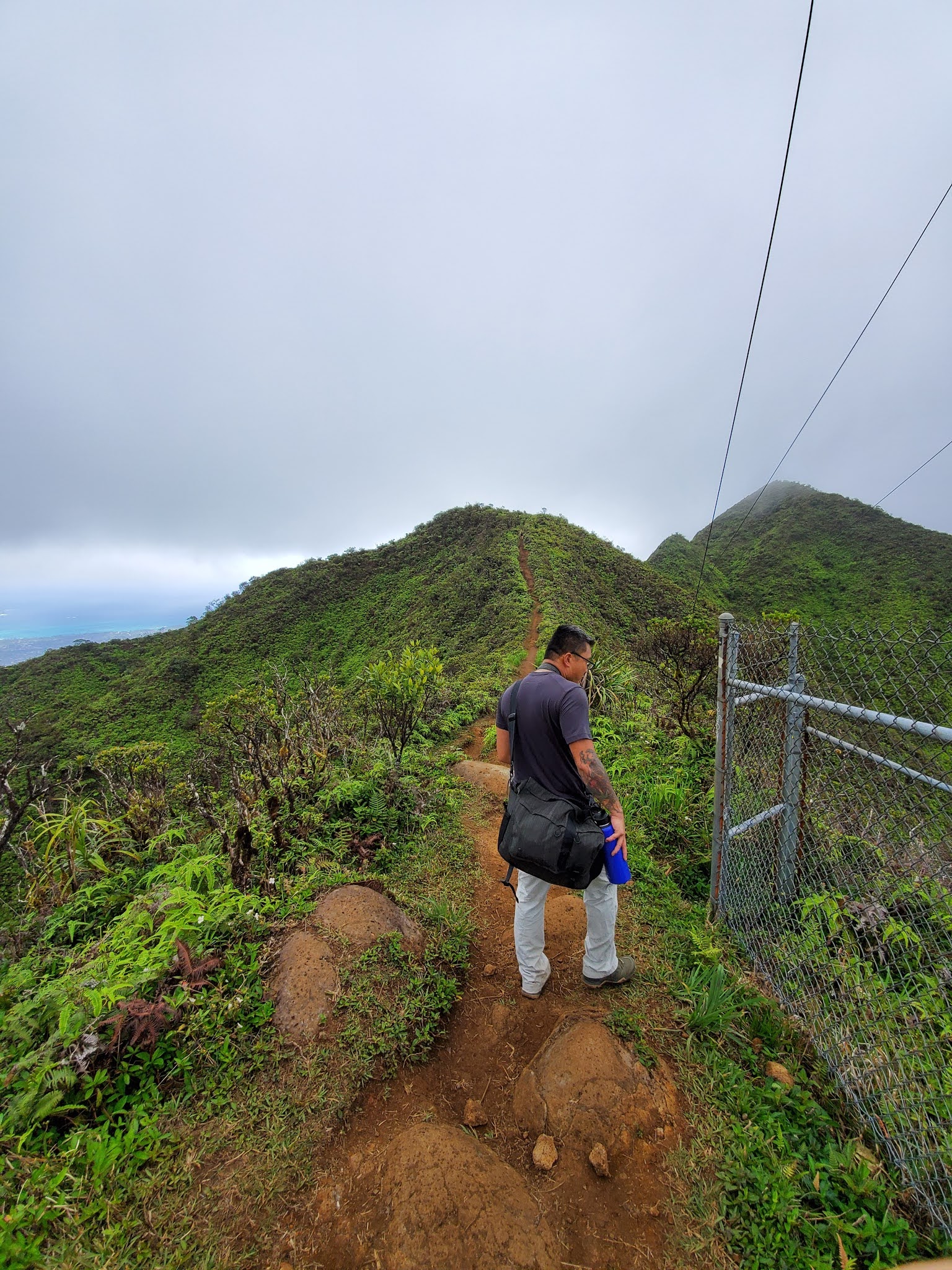
The end is for real in sight now, though. That station area marks where it just levels out, and you just need to walk along a nice, gentle ridge to get to the other summits. Easy peasy lemon sneezy.

But in the meantime.

You have to do this:

And this:

And this. Which do not collectively look bad, but they were super fucking slippery and steep and just a general bummer to my 36 year old body.


I think looking at the stairs after you've climbed them shows better what kind of nonsense you're dealing with as far as an incline goes. But also, that view. Even on a cloudy day, with a cell phone that HDRs the fuck out of everything, it's beautiful.

So, when we got to the top of these steps, I needed a five minute break. Like, bad. I needed water, I needed a snack (I brought almonds. What a moron. Almonds did not cut it), I needed to hurl myself off the side of the ridge to avoid more stairs. I figured I'd cover my need for death by taking some photos, in an attempt to talk myself out of it.


It worked, and on we pressed.
UGH. But this is the second to last ascent before you could turn around and say you did Wiliwilinui until the end and not be called a liar.

A change of pace: This is a view to the side of me:

And to the side, but more differenter:

HERE IT IS! The fucking final boss bastard set of stairs until getting to the station. My salvation!!!


WE MADE IT!!!!!! Those stairs were fucking GRUELING. Just...just not the greatest.
And there's the ridgeline up to the summit, but real!

O'ahu traffic.

Here's the hot man piece, and I remember why I beat him to the top. He was taking pictures of...I want to say a daisy through the chain link fence. He stayed right where he's at in this photo for a solid fifteen minutes.

On our way to the second summit!


It's just so fucking GREEEEEEEEEEEEEEEEEEEEEEEEN. And it was also windy as balls.


The final ascent. For real this time.


Wait wait! These stairs are the really real final ascent. I promise. But, these stair shots were taken on the way back down. We really jetted back down, we barely stopped. I think the entire hike took us three hours total.


That is a sharp incline/decline, you guys.


Update: So, my phone says we started this hike at 1:07pm, but my lightroom info says my photos of the summit were taken at 10:30 am. That sounds more correct than 1pm. I'm sticking with that.
Also, these photos are so bad. I say all the time that I'm not a landscape photographer, but it is rarely as evident as it is in these photos. In fairness to me, I was taking them for posterity and not artistic merit, but I still always want all of my photos to look like I'm just the most amazing at all aspects of photography.
So this is crazy dehazed, which is why it looks so, uh...shit.

Here's the assumed Lion's Mane!


A peak down through the valley.


Diamond Head! I wish I had documented that like I documented all of our hikes the last year on island.

I think that's Hanauma, but I can't be sure.

Those're the second and third peaks on Olomana Trail!

There's Olomana Trail in all its glory.

And there we are! Wiliwilinui Ridge. I'm so glad we got to do that hike. Those stairs were awful, but I'd do them again. Maybe. Possibly. Kinda?
No comments:
Post a Comment